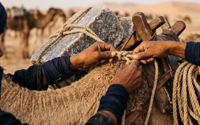
Analyze the Tuareg as the strategic “link-people” of the Sahel. Discover how their mastery of routes, trust-based networks (Amana), and Tifinagh script create a unique form of mobile sovereignty.


The Sahel is not merely a transition zone; it is a shore. Derived from the Arabic word sāḥil (ساحل), it marks the edge where the sandy ocean of the Sahara meets the first savannas.
Too often reduced to its western portion, the Sahel is actually a continental belt stretching 5,400 kilometers. From the Atlantic to the Red Sea, it traverses Africa like a massive artery where people, ideas, and goods have circulated for millennia. To understand the Sahel is to embrace a cultural and ethnic crossroads without equal, where life paths—our Lifelines—defy the straight, artificial lines of colonial maps.
Analyze the Tuareg as the strategic “link-people” of the Sahel. Discover how their mastery of routes, trust-based networks (Amana), and Tifinagh script create a unique form of mobile sovereignty.
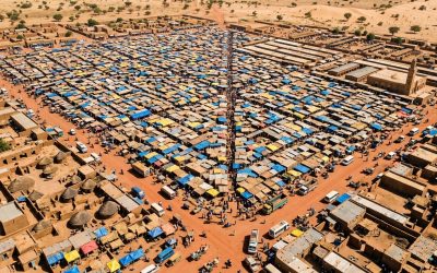
The Sahel is a space of flow. Explore the Hausa trajectory, the ‘invisible operating system’ of West Africa, and how their alliances form the true bedrock of regional resilience.
Surface Area: Approximately 3 million km² (nearly 6 times the size of France).
Extent: A band 5,400 km long and 300 to 500 km wide.
Climate: Semi-arid. Rainfall concentrated over 2 to 4 months (monsoon).
Rainfall: Ranging from the 200 mm isohyet (north) to 600 mm (south).
Countries Traversed: Senegal, Mauritania, Mali, Burkina Faso, Niger, Nigeria (north), Chad, Sudan, Eritrea, Ethiopia (north).
By flanking the Sahara across its entire width, the Sahel has fostered a unique zone of cultural blending. Here, the Berber and Moorish worlds meet Sub-Saharan civilizations.
This is the land of the Fulani, migratory herders whose cattle ignore border posts. It is the heartland of the Hausa, whose language is the bedrock of West African trade. It is the domain of the Tuareg, the Songhai, the Kanuri, and the Sudanese peoples.
In this region, every ethnic group carries a “Lifeline”: a distinct way of navigating the desert, managing water, trading, and building solidarity. In this section, we move beyond clichés to analyze how these peoples adapt, resist, and redefine their identities in the face of 21st-century challenges.
Surface Area: Approximately 3 million km² (nearly 6 times the size of France).
Extent: A band 5,400 km long and 300 to 500 km wide.
Climate: Semi-arid. Rainfall concentrated over 2 to 4 months (monsoon).
Rainfall: Ranging from the 200 mm isohyet (north) to 600 mm (south).
Countries Traversed: Senegal, Mauritania, Mali, Burkina Faso, Niger, Nigeria (north), Chad, Sudan, Eritrea, Ethiopia (north).
Analyze the Tuareg as the strategic “link-people” of the Sahel. Discover how their mastery of routes, trust-based networks (Amana), and Tifinagh script create a unique form of mobile sovereignty.
The Sahel is a space of flow. Explore the Hausa trajectory, the ‘invisible operating system’ of West Africa, and how their alliances form the true bedrock of regional resilience.
By flanking the Sahara across its entire width, the Sahel has fostered a unique zone of cultural blending. Here, the Berber and Moorish worlds meet Sub-Saharan civilizations.
This is the land of the Fulani, migratory herders whose cattle ignore border posts. It is the heartland of the Hausa, whose language is the bedrock of West African trade. It is the domain of the Tuareg, the Songhai, the Kanuri, and the Sudanese peoples.
In this region, every ethnic group carries a “Lifeline”: a distinct way of navigating the desert, managing water, trading, and building solidarity. In this section, we move beyond clichés to analyze how these peoples adapt, resist, and redefine their identities in the face of 21st-century challenges.